No products in the cart.


Sale!


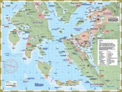

Deck Topper Mapsheet – Desolation Sound South
Original price was: $18.95.$13.27Current price is: $13.27.
- Control the delivery date and try to deliver it in the fastest time
- Superior Quality Goods
- Shop with Zero Worries
- Shop with confidence, enjoy free returns.

Product Details
Deck Topper Mapsheet – Desolation Sound South Description
- Designed by kayakers and explorers who are experts in this region.
- Includes full coverage of Desolation Sound Marine Provincial Park and adjacent regions including the Copeland Islands. Northern extent is Roscoe Bay, Refuge Lagoon, Squirrel Cove and Carrington Bay. Southern extent is Lund and Savary Island.
- All land and marine features of interest, including campsites, launch points, rest stop, attractions and hazards.
- UTM grid lines for easy distance calculations. Learn to understand and make the most of them.
- Our in-house printing allows frequent product updates to ensure the latest information.
- Printed on extremely waterproof/durable 10-mil stock when 4.3-mil stock is the norm.
- Planning and logistical information is included on the opposite side of the main map to help make your adventure come to life.
- Optimal size and format for use both at home for planning and on-water during your travels.
- Augment your GPS navigation with a handy visual overview as you travel and as you plan your next day’s agenda. In combination you will be well prepared for your adventure.
- Use alone without electronic assistance by navigating the traditional way without reliance on batteries or connectivity. Truly disconnect!
Be the first to review “Deck Topper Mapsheet – Desolation Sound South”
Related products
Sale!
Hobie Parts & Accessories
Original price was: $144.95.$96.99Current price is: $96.99.
Sale!
Hobie Parts & Accessories
Original price was: $34.25.$23.98Current price is: $23.98.
Sale!
Hobie Parts & Accessories
Original price was: $359.00.$98.99Current price is: $98.99.
Sale!
Hobie Parts & Accessories
Original price was: $12.00.$8.40Current price is: $8.40.
Sale!
Other Items
Original price was: $340.00.$97.99Current price is: $97.99.
Sale!
Hobie Parts & Accessories
Original price was: $25.95.$18.17Current price is: $18.17.
Sale!
Kayak Fishing Gear
Original price was: $35.00.$24.50Current price is: $24.50.
Sale!
Hobie Parts & Accessories
Original price was: $23.95.$16.77Current price is: $16.77.
Reviews
There are no reviews yet.