No products in the cart.


Sale!


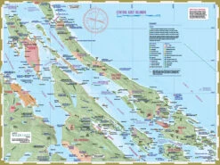

Deck Topper Mapsheet – Central Gulf Islands
Original price was: $18.95.$13.27Current price is: $13.27.
- Control the delivery date and try to deliver it in the fastest time
- Superior Quality Goods
- Shop with Zero Worries
- Shop with confidence, enjoy free returns.

Product Details
Deck Topper Mapsheet – Central Gulf Islands Description
This mapsheet covers the waterways in the central section of the Gulf Islands,notably Galiano Island in an unbroken unit. Key attractions are the many provincial parks including Wallace Island and Dionisio, among others.
The mapsheet layout
The layout is a regional overview on the full page of one side, and on the other side a detailed closer-perspective view of Nanaimo Harbour as well as a regular scale showing Gabriola Island. Also included are planning details such as expected water conditions, trip planning information and campsite information.
The mapsheet construction
The mapsheet is created by Wild Coast Publishing using some of the latest technology available to provide a high-quality printed image on waterproof/durable synthetic polymer stock. The stock is picked as the best for the purpose, and is significantly thicker than most papers at 10 mil weight.
Be the first to review “Deck Topper Mapsheet – Central Gulf Islands”
Related products
Sale!
Kayak Fishing Gear
Original price was: $24.00.$16.80Current price is: $16.80.
Sale!
Kayak Fishing Gear
Original price was: $61.99.$43.39Current price is: $43.39.
Sale!

Other Items
Original price was: $398.00.$99.99Current price is: $99.99.
Sale!
Hobie Parts & Accessories
Original price was: $12.00.$8.40Current price is: $8.40.
Sale!
Other Items
Original price was: $340.00.$97.99Current price is: $97.99.
Sale!

Original price was: $38.95.$27.27Current price is: $27.27.
Sale!
Kayak Fishing Gear
Original price was: $32.99.$23.09Current price is: $23.09.
Sale!
Original price was: $180.00.$96.99Current price is: $96.99.
Reviews
There are no reviews yet.